

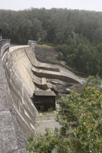
An amazing piece of engineering is Chichester Dam on top of Barrington Tops. It was built between 1917 and 1926. An enormous pipe runs from that dam to Newcastle. If you ever get to Dungog and drive past the Ladies Bowling Club it won’t take you long to spot an enormous steel pipe snaking its way over paddocks and past small villages. This pipe is in sections, supported by many concrete stanchions.
If you are al all curious about this strange intrusion, just keep following the pipe and you should arrive at the Chichester Dam road. If you park the car and follow the pipe on foot to the dam you will have a magic walk. It is one of those hidden treasures that seem to have got lost in advertisements urging for tourists to go to Bondi or Byron Bay. The road finally takes you to the brick built gates and entrance to the area of the Chichester Dam itself.
While the building of the harbour bridge was of a much greater significance, Chichester dam is a great engineering achievement.
Here some information from a website:
The catchment for Chichester Dam is largely within the Barrington Tops National Park, which is a declared wilderness area. As a result it is one of the most pristine catchments in Australia with large areas unaffected by human activity.
Chichester Dam statistics
| Catchment area | 197 square kilometres |
| Location | Located at the top of the Williams River catchment |
| Available Capacity | 21,500 megalitres |
| Surface area of dam | 180 hectares |
| Maximum depth | 37 metres |
| Average daily supply | 90 megalitres |
| Main Embankment Length | 254 metres |
| Wall Height | 43 metres |
| Spillway length | 112 metres |
| Thickness crest | 3.7 metres |
| Thickness bass | 27.4 metres |
| Full Supply Level RL(reduced level) | 156.2 metres ASL (above sea level) |
| Construction | The wall is 254m long and 43m high, and is a ‘cyclopean’ system of interlocking concrete blocks and large boulders, each approximately 230 cubic metres. The wall is anchored to the bedrock below the wall by 93 stressed tendons. |
Chichester Dam history
Chichester Dam is the oldest water storage facility currently in use within the Hunter and was completed in 1926, although the dam provided its first supply of water to the community in 1923. Before its construction the Hunter relied on water from the Walka Water Works which drew water from the Hunter River near Maitland. Operations at Walka were interrupted by flood and drought, and the water was considered by many to be too ‘hard’.
A more reliable source with a greater capacity to store water was required for both a growing population and the industrial development of the region, which included the Sulphide Corporation at Cockle Creek (1896) and the BHP Steel Mill at Port Waratah (1915). In 1915 the Parliamentary Standing Committee on Public Works advised the NSW Government that a storage dam be built on the Chichester River. Land was gazetted in 1916 and houses for construction workers were erected at Dusodie.
The workers’ health was improved by the provision of a doctor, reticulated water from the Chichester River, hot and cold showers, and a sanitary service. Dwellings were made for families, while single men slept in barracks of about ten beds each. The men erected their own reading room, dance hall and billiards room for Dusodie’s one thousand residents. In the hill above the dam site, a terrace was excavated to allow concrete making plants.
A nearby sawmill supplied timber, which was hauled on wooden tramlines, while a quarry supplied stone and gravel. Two steamdriven cableways, each spanning 335-metres across the gorge, delivered concrete and materials to the workforce. Sand was transported from Newcastle in steam-powered Sentinel trucks, while horse-drawn vehicles carried pipes and other materials.
Upgrades and modifications
As our oldest dam, Chichester has been extensively upgraded and modified to meet changing demands and ensure safety and reliability of supply. Major works include:
- 1965: spillway lowered by 2.75m to increase flood capacity
- 1985: dam post-tensioned with cables, spillway relocated to centre of the dam wall and returned to original height
- 1995: seepage potential reduced under the northern abutment
- 2003: improved drainage system for foundations installed and the left parapet wall raised to prevent overtopping in major flood

Dam good piece, Gez! And nice piccies too…
🙂
LikeLike
Thanks Gez.
Us Novocastrians are grateful for the foresight of our earlier leaders. Thanks to them, the last water restrictions were in 1990. There are supplementary water sources, such as, the Grahamstown Dam plus the Tomago and Anna Bay sand beds, where water can be drawn from aquifers beneath the sand. Hunter Water is planning to construct a second dam, the Tillegra, further up the valley, to plan for future growth (us cynics suspect it is to supply water for coal mines which consume enormous volumes of water to wash the coal).
Gez, if you follow those enormous pipes into Newcastle, they terminate in a small dam in North Lambton which is adjacent to the ‘Water Board Bowling Club’, so, we’re back to the bowlo!
LikeLike
I do like a good dam.
Suma Park will overflow sometime in the next week for the first time since 2005, and aren’t the good burghers of Orange agog at that. Revelling in the fact that their water restriction have been dropped from Level 5, (shot on sight using a hose) to level two, (never mind, the dam’s full, fill ya boots!) after the wettest August on record. Nothing like a La Nina to get all the rivers running.
LikeLike
Dam good statistics Gez
LikeLike
Don’t you dare make hand-made relief a tag Hung.
LikeLike
Who? me
LikeLike